Welcome
The APEx Geospatial Explorer is an interactive web map application used to display and visualise outputs from Earth Observation projects. EO Project teams typically use the "GE" to support the communication of their results with interested stakeholders.
The user interface structure, the content that it serves and the functionality presented in a given GE "instance" are all defined in a JSON configuration file that the GE reads at run time. A GE Configuration Builder tool has been produced that allows config authors - anyone who builds or maintains a GE configuration - to develop and maintain a config file, without needing familiarity with JSON or the specific schema that the GE uses. This guide provides a task focussed explanation on what the configuration builder tool does and how to use it.
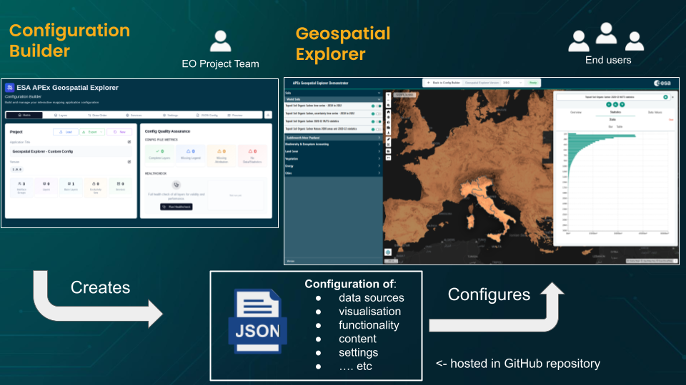 The EO Project Team uses the Configuration Builder to author a JSON config (data sources, visualisation, functionality, content, settings). The config is hosted in a GitHub repository and consumed by the APEx Geospatial Explorer to deliver the configured experience to end users.
What you can do with the builder
- Compose an APEx Geospatial Explorer configuration from data sources and services (WMTS, WMS, WFS, COG, XYZ, GeoJSON, FlatGeoBuf, CSV) using layers organised into interface groups
- Define the background maps that are available
- Style raster layers with categories and colormaps, build RGB composites and style vector layers with rule-based filters and stops.
- Define statistics and constraint layers
- Author charts from CSV, COG pixel values, or vector feature properties.
- Configure specific functional controls for each layer - e.g opacity slider, download links
- Browse remote catalogues with the STAC and S3 browsers.
- Inspect the metadata of data sources to understand their content
- Validate every URL in your config with the Run Healthcheck tool and see data-access plus performance scores at a glance.
- Define specific branding and navigation defaults (e.g. projection; start location and scale)
- Preview the resulting APEx Geospatial Explorer inline using GE Preview before exporting JSON.
Where to start
Pick the entry point that matches what you are doing right now:
| If you are… | Start here |
|---|---|
| New to the builder | Getting Started → Overview — core concepts (config, service, layer, interface group). |
| Building your first config from scratch | Build your first config — guided walk-through. |
| Evaluating a config you just loaded | Run Healthcheck — fastest way to find broken or slow layers. |
| Looking for a specific feature | Use the left-hand nav, grouped by tab (Home, Layers, Services, Settings…). |
| Editing the documentation itself | Authors guide. |
Conventions used in this guide
- Bold for UI labels you click or type into.
codefor filenames, URL fragments, and JSON field names.- Screenshots in this guide were captured with the Comprehensive demo example config loaded — you can load it yourself from Home → Load → Examples to follow along.
- The terms layer and data source are used interchangeably; internally
the config calls them
sources. - Coordinate systems are always called CRS (Coordinate Reference System), never "projection".